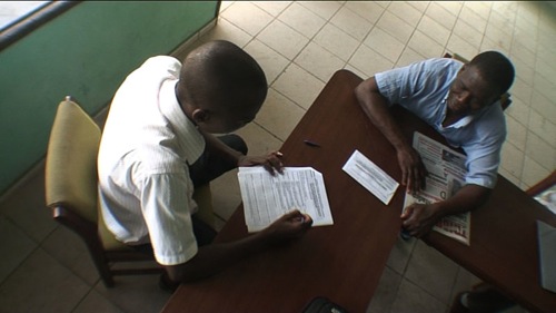
Txteagle in Flight: Mobile Data Collection for Disaster Preparedness data sheet 4852 Views
Txteagle is a data collection and engagement platform that leverages mobile airtime compensation for data collection and customer engagement. It is currently used by one nonprofit organization to survey constituents about disaster preparedness. We looked into the company and one of its customers.
Txteagle widely advertises its ability to reach 2.1 billion mobile subscribers currently. MobileActive.org spoke with Nathan Eagle, co-founder of the service, to learn more about how it works, how many active participants there are and where some of the large numbers come from. We also spoke with Terry Gibson, project manager for the Global Network of Civil Society Organisations for Disaster Reduction, who is currently using txteagle to collect mobile data on 40,000 respondents in 48 countries.
FOLKSOMAPS - Towards Community Driven Intelligent Maps for Developing Regions data sheet 1317 Views
Author:
Kumar, Arun, Dipanjan Chakraborty, Himanshu Chauhan, Sheetal K. Agarwal, and Nitendra Rajput
Publication Date:
Jan 2009
Publication Type:
Report/White paper
Abstract:
Many services taken for granted in the developed world are often missing from the developing countries. One typical example is that of map systems that form the basis of several location-driven services. Its heavy reliance on content, provides a huge barrier towards building such systems. Further, in developing countries like India, the infrastructure typically has a history of unplanned development, leading to unorganized addresses and absence of standard naming conventions for roads. Detailed map systems such as online maps have only recently started becoming available but for major cities. Remote towns and villages remain out of reach till date.
In this paper, we investigate a community-driven approach for creating maps in developing regions - following Web 2.0 principles, but not entirely relying on the existing Web. Our system, dubbed FOLKSOMAPS is an intelligent, community constructed map system, particularly architected with developing regions in mind. We present the design of FOLKSOMAPS, followed by an implementation of our proof-of-concept system. We present user studies aimed at understanding the uptake, usability and utility of FOLKSOMAPS. The results indicate a strong need for such a community-generated mapping ecosystem.
The Global Network of Civil Society Organisations for Disaster Reduction is a major international network of civil society organizations committed to working together to influence and implement disaster risk reduction policy and practice at the local, national and international levels.
The radio station WNYC is creating on-air and online stories from two things very familiar to people in the Northeastern United States: mobile phones and snow. A snowstorm over the holidays was the heaviest December snowfall in six decades and dumped up to 20 inches in many parts of New York City. The story quickly became one of snow removal and how the city was not removing the snow as quickly as people had hoped.
Jim Colgan and the WNYC newsroom wanted to get a sense of what was happening on the streets. Problem was, there was no good or easy way to do this. The station couldn’t rely on the city for real-time information, and reporters couldn’t get to many of the areas. The answer was to have the listeners share their own reports and stories, via mobile phone.
Texting to 9-1-1: Examining the Design and Limitations of SMS data sheet 1383 Views
Author:
4G Americas
Publication Date:
Oct 2010
Publication Type:
Report/White paper
Abstract:
This analysis focuses on SMS as a means to contact 9-1-1 emergency services, with a goal to provide a view of the capabilities, limitations, threats and vulnerabilities of this means of communications. There are millions of SMS messages sent each day and there is a perception that SMS is reliable; however, SMS was never designed as a reliable means for life-saving critical communications. SMS was designed to be secondary to voice calls and was never designed to provide the full and robust communications citizens have come to expect with voice calls. SMS has significant limitations and shortcomings that do not make SMS suitable for emergency communications, especially under life threatening conditions. In conclusion, there are significant limitations inherent in the design of the current Short Message Services which make it impractical to be used for emergency service. However, the industry is fully aware that it is important to address the requirements for people with disabilities as soon as possible. To that end, it is recommended that techniques which are readily available today, such as silent 9-1-1 calls, along with accelerating research and development into emerging technologies such as TTY Emulation, be undertaken while the next generation systems are being designed.
Barriers and Gaps Affecting mHealth in Low and Middle Income Countries: Policy White Paper data sheet 1605 Views
Author:
Mechael, Patricia, Hima Batavia, Nadi Kaonga, Sarah Searle, Ada Kwan, Adina Goldberger, Lin Fu, and James Ossman
Publication Date:
May 2010
Publication Type:
Report/White paper
Abstract:
Still in its infancy, mHealth, the use of mobile technologies for health, runs the risk of not realizing its full potential due to small-scale implementations and pilot projects with limited reach. To help shed light on these issues, the mHealth Alliance commissioned an in-depth exploration of the policy barriers and research gaps facing mHealth. The review identified significant gaps in mHealth knowledge stemming from the limited scale and scope of mHealth implementation and evaluation, a policy environment that does not link health objectives and related metrics to available mHealth tools and systems, and little investment in cost-benefit studies to assess mHealth value and health outcomes research to assess success factors and weed out poor investments.
As illustrated throughout the literature, the current single-solution focus of mHealth needs to be replaced by using mHealth as an extension and integrator of underlying health information systems along the continuum of care. Creating a strong collaborative foundation will be instrumental in driving and positioning public and private investment in mHealth in a way that contributes to achieving improved access to health information and services, health outcomes, and efficiencies.
Within such structured paradigms, planning for infrastructure investment and human resources capacity strengthening and identifying public and private stakeholders within the ecosystem to take leadership for the development, testing, implementation, and evaluation of mHealth activities can be appropriately mapped and planned and mHealth services more effectively extended to support the health of citizens and the work of health professionals and administrators.
In part one of "How to Work With Operators," we investigated key considerations for mobile-for-change projects that, for better or worse, have to deal with mobile operations. In this second part of the series we look at the ten top tips for a successful relationship. While there is no one-size fits all approach or recommendation for a successful relationship, here are some tips for approaching, building, and sustaining a solid business relationship with a mobile provider.
A new report from the Knight Foundation analyzes how new technologies were used to aid in the recovery of the earthquake in Haiti. The report -- Media, Information Systems and Communities: Lessons from Haiti -- suggests that the events mark "the beginning of a new culture in disaster relief" in which new and hybrid technologies, including mobile phones, are used to support rescue and relief efforts.
The report mentions a numnber of uses of mobile technology, including:
Interactive maps and SMS helped search-and-rescue teams find people in need of supplies
SMS messages broadcast critical information to Haitians
Hybrid approaches in which mobile technology was used in conjunction with radio
Mobile-based projects for social change can be found in any issue area: mobile health, mobile money, initiatives that promote advocacy, citizen journalism, democratic participation, and economic livelihoods. While projects vary in scope, objectives, and platforms, one consistency between many successful projects is a good working relationship with the mobile network operator in a given country.
Mobile network operators, or MNOs, go by many names: mobile providers, cell providers, telecommunications companies. In this article, we focus on MNOs in the traditional sense: companies that provides mobile network services.
The app addresses stockouts and market connectivity problems for remote users. in general, it lowers costs and increases performance for the flow of goods to and from villages. For village producers (of crops, milk, arts, crafts and textiles) it serves as a market connection mechanism (like Craig's list). For village consumers (of medicines, healthcare, and retail goods) it optimizes inventory policy for the shopkeeper to maintain reliable availability.
Samaanguru is a robust mobile supply chain management platform that addresses stock visibility, inventory control, order management, demand forecasting, optimization, and analytic visualization of transactional activity.
Tool Category:
App resides and runs on a mobile phone
Is a web-based application/web service
Key Features :
Mobile stock counts, issues (sales), receipts (purchases), order placement, order view/negotiate/confirm, and material information displays.
Configurable browser-side demand board, mapping, reports, analytics, etc.
It's an out-of-the-box configurable supply chain management toolkit.
Main Services:
Other
Information Resources/Information Databases
Display tool in profile:
Yes
Tool Maturity:
Currently deployed
Release Date:
2011-09
Platforms:
Java ME
All phones/Mobile Browser
Current Version:
1.9
Program/Code Language:
Java
Languages supported:
English
Handsets/devices supported:
All feature phones supporting Java MIDP 2.0 or higher (Nokia, Sony Ericsson, Samsung, Micromax, Chinese knock-offs, etc.) Some Android handsets (because they support Java apps)
If you're interested in using mobiles and ICTs for data collection, the sheer number of tools and projects can be overwhelming. With so much out there, the need to highlight good projects and consolidate practical information is clear. Here is a handy reference guide to all the data collection information we've accumulated on MobileActive.org.
The Ultimate Resource Guide
We recently created the Ultimate Resource Guide, an easy-to-use spreadsheet that breaks down our data collection content into clear categories:
Web content: A compilation of blog posts, case studies, and regular posts that focuses on data collection.
Peer Reviewed Research: A collection of journal articles, research papers, and literature reviews related to mobile data collection.
Reports and Evaluations: A matrix of 20+ case studies, broken down by issue, area of practice, target country, and type of evaluation.
How-Tos: Instructions for setting up many of the most popular data collection tools, such as ODK, RapidSMS, and EpiCollect.
Inventory: An inventory of current data collection projects around the world, compiled through user submissions and MobileActive's research. Thanks to all who contributed!
Comparison Matrix
We developed a comparison matrix assessing ten different mobile data collection tools against a core set of metrics, both technical (platforms, data type collected, required operating systems, security, etc...) and non-technical (such as cost, language, and support). If you want to implement a data collection project, the comparison matrix can help you to determine which tool is best for your project.
Research
There is a great deal of academic and analytic research on mobile data collection. For example, check out these two practical pieces that examine how mobiles and ICTs are used in the field:
Our slidecast that examines the effectiveness of PDA-based questionnaires vs. paper questionnaires for collecting health data in Fiji.
A literature review that provides an overview of the components, approaches, and techniques used to build mobile phone-accessible, SMS applications for data collection and service delivery.
We recently developed a comparison of mobile data collection tools. Thank you to all of you who provided valuable feedback. Here's what's been added and changed from the draft version:
We added two tools: GeoChat and GATHERdata.
Added FrontlineForms to the FrontlineSMS description.
Three fields have been added to all tools: form question and logic overview, native data analysis/reports, and data export.
Integrated comments on existing material into the spreadsheet.
We'll add and revise tools regularly. Please comment and tell us what's missing!
Audience
The matrix is aimed at program managers, or those in similar roles, whose responsibility it is to choose the best mobile data collection technology for their project.
The PoiMapper application allows a user to create a case-specific questionnaire, collect data, and upload it to a database. PoiMapper also allows the user to take photographs of specific points of interest (POIs) being recorded and these images are also uploaded to the database. Another feature is that the system can be used to update existing data.
Tool Category:
App resides and runs on a mobile phone
Is a web-based application/web service
Key Features :
1. Define program specific point-of-interests (POIs), routes and areas with associated data to be collected. Data can be of multiple types: text, numbers, single and multi-choice alternatives, conditional sub-questions.
2. Capture pictures to be included for POIs.
3. Collect data with affordable mobile phones with GPS and camera.
4. Upload data directly to a central database over the cellular network or via an internet connected computer, edit existing data in the mobile device during follow-up visits.
5. Back-office reporting and analysis.
6. Visualize the collected data in different ways.
PoiMapper: Mobile Data Collection Through Points-of-Interest in Kenya data sheet 3202 Views
PoiMapper, a product from Pajat, is a mobile application for data collection, hosting, and sharing. It works on a feature phone with Java capability and allows a user to design a case-specific questionnaire to collect field data, including numbers, text, and photo images. Through this, it supports the collection of point-of-interest (POI) data -- hence the name, PoiMapper -- and is currently being tested in this capacity in Kenya in collaboration with Plan Kenya, Plan Finland, Helsinki University of Technology, and University of Nairobi. The pilot is ongoing and an evaluation is to be done a month from now.
The aim of the NGO is to promote the use of the Geographic Information Systems (GIS) in the context of the relief work, emergency and development. CartONG would like to develop the exchanges of geographic information between the NGO's, or association involved in the humanitarian work.
There are a myriad of mobile data collection tools, and varied documentation describing what they do, what they require, and how they work. Given these choices, choosing a particular system can be a daunting task.
We recognize this challenge and have developed a DRAFT matrix assessing ten different mobile data collection technologies against a core set of metrics. It does not seek to emphasis one over the other, rather is meant to aid you in determining which is best for your project. Please take a look at this draft and annotate and edit, as appropriate. Given the quick changes in this area, this is a work in progress.
Thank you to my colleague at MobileActive.org, Mohini Bhavsar, whoe helped compile the data, and the many people who made themselves available to vet the data in the spreadsheet.
Get ready for a month of mobile events with something for everyone! Interested in how ICTs can be used to help civil society organizations, or help manage crises? Or do you want to develop and monetize apps? This month, we've got you covered:
2 November, Global Pulse Tech Salon (New York City, USA): Interested in learning about how ICTs can be used during crises? The Global Pulse Tech Salon is hosting a gathering to focus on crisis management through data collection, citizen engagement, and the use of communications technologies.
2-4 November, Planet of the Apps(London, UK): This app-focused event is mainly for corporate brands and operators, with panels and presentations on building and marketing engaging apps.
As part of a pilot project in Uganda, Refugees United is using mobile tools to help connect refugees who have been displaced by war, persecution, and natural disasters.
Since the devastating earthquake in Haiti in January, thousands of internally displaced persons are living in camps, where it is often not easy to report incidences of violence. An ongoing project from Survivors Connect uses mobile phones to support camp managers and community leaders to protect women and encourage people to report incidences.
Can you find me now? Refugees United Goes Mobile to Help Reunite Refugees data sheet 3823 Views
As part of a pilot project in Uganda, Refugees United is using mobile tools to help connect refugees who have been displaced by war, persecution, and natural disasters. Refugees United is a Danish NGO that designed and runs a web-based program to help people directly reconnect with missing loved ones. For the mobile pilot, it is working in conjunction with the UN High Commissioner for Refugees (UNHCR), mobile phone maker Ericsson, MTN, a mobile telecommunications company in Africa and specifically MTN Uganda, as well as other partner organizations on the ground.
The Mobile Minute has info on social networking via mobiles, interactive mobile lesson plans in South Africa, a new ITU study that estimates more than 90% of the world's population has access to mobile networks, the Red Cross' work to battle a cholera outbreak in Haiti with SMS health updates, and the launch of a mobile money transfer pilot in the Philippines.
The main problem is field staff unable to view and edit activity and indicator data when working in geographic areas with low or no internet connectivity. Without consistent data entry from field staff, reporting and project management loses its effectiveness. Cohort Mobile Lite provides field staff with a tool to manage workplan and results data to contribute to the collaboration on enterprise project portfolio management.
Cohort Mobile Lite runs on Windows mobile devices and provides workplan (activity and task) as well as results (indicators) management functions. Cohort Mobile Lite works with Cohort Mobile, the offline edition, and Cohort Central, the web-based enterprise edition, to provide a complete project management environment for international development, humanitarian assistance, and relief organizations. Cohort Mobile Lite is a scaled-down version of our enterprise software; this application allows field staff to enter and view project data without consistent internet connectivity.
Mobile phone users want to display other maps instead of just Google maps on their devices. Mobile GMaps enables users to view Yahoo! Maps, Windows Live Local, Ask. com, Open Street Map, and other sources on Java J2ME-enabled mobile phones, PDAs, and other devices.
Mobile GMaps is a free application that displays maps from Google Maps, Yahoo! Maps, Windows Live Local (MSN Virtual Earth), Ask.com, Open Street Map and other sources, but only on Java J2ME-enabled mobile phones, PDAs and other devices. MGMaps can connect to a GPS receiver over bluetooth or use internal GPS features on some phones in order to automatically display the map for your current position. You can pre-download maps and store them on your memory card in order to use them on the go without accessing the network.
Mobile GMaps is distributed under the Attribution - NonCommercial - NoDerivs Creative Commons license. You may download, use and distribute the application free of charge only for personal, non-commercial purposes.
Tool Category:
App resides and runs on a mobile phone
Key Features :
Mobile GMaps enables users of Java J2ME-based feature phones to view maps from a variety of sources. The creator is constantly improving this application and you can view past versions for download. There is also a G-Map Track BETA feature that allows you to view public Google maps and see a map of you and your friends. API for this application is coming soon.
Editor’s Note: In this article, guest contributor Paul Currion looks at the potential for crowdsourcing data during large-scale humanitarian emergencies, as part of our "Deconstructing Mobile" series. Paul is an aid worker who has been working on the use of ICTs in large-scale emergencies for the last 10 years. He asks whether crowdsourcing adds significant value to responding to humanitarian emergencies, arguing that merely increasing the quantity of information in the wake of a large-scale emergency may be counterproductive. Instead, the humanitarian community needs clearly defined information that can help in making critical decisions in mounting their programmes in order to save lives and restore livelihoods. By taking a close look at the data collected via Ushahidi in the wake of the Haiti earthquake, he concludes that crowdsourced data from affected communities may not be useful for supporting the response to a large-scale disaster.
1. The Rise of Crowdsourcing in Emergencies
Ushahidi, the software platform for mapping incidents submitted by the crowd via SMS, email, Twitter or the web, has generated so many column inches of news coverage that the average person could be mistaken for thinking that it now plays a central role in coordinating crisis responses around the globe. At least this is what some articles say, such as Technology Review's profile of David Kobia, Director of Technology Development for Ushahidi. For most people, both inside and outside the sector, who lack the expertise to dig any deeper, column inches translate into credibility. If everybody's talking about Ushahidi, it must be doing a great job – right?
Maybe.
Ushahidi is the result of three important trends:
Increased availability and utility of spatial data;
Rapid growth of communication infrastructure, particularly mobile telephony; and
Convergence of networks based on that infrastructure on Internet access.
Given those trends, projects like Ushahidi may be inevitable rather than unexpected, but inevitability doesn't give us any indication of how effective these projects are. Big claims are made about the way in which crowdsourcing is changing the way in which business is done in other sectors, and now attention has turned to the humanitarian sector. John Della Volpe's short article in the Huffington Post is an example of such claims:
"If a handful of social entrepreneurs from Kenya could create an open-source "social mapping" platform that successfully tracks and sheds light on violence in Kenya, earthquake response in Chile and Haiti, and the oil spill in the Gulf -- what else can we use it for?"
The key word in that sentence is “successfully”. There isn’t any evidence that Ushahidi “successfully” carried out these functions in these situations; only that an instance of the Ushahidi platform was set up. This is an extremely low bar to clear to achieve “success”, like claiming that a new business was successful because it had set up a website. There has lately been an unfounded belief that the transformative effects of the latest technology are positively inevitable and inevitably positive, simply by virtue of this technology’s existence.
2. What does Successful Crowdsourcing Look Like?
To be fair, it's hard to know what would constitute “success” for crowdsourcing in emergencies. In the case of Ushahidi, we could look at how many reports are posted on any given instance – but that record is disappointing, and the number of submissions for each Ushahidi instance is exceedingly small in comparison to the size of the affected population – including Haiti, where Ushahidi received the most public praise for its contribution.
In any case, the number of reports posted is not in itself a useful measure of impact, since those reports might consist of recycled UN situation reports and links to the Washington Post's “Your Earthquake Photos” feature. What we need to know is whether the service had a significant positive impact in helping communities affected by disaster. This is difficult to measure, even for experienced aid agencies whose work provides direct help. Perhaps the best we can do is ask a simple question: if the system worked exactly as promised, what added value would it deliver?
SMS SOS: Reporting Gender-Based Violence in Haiti data sheet 4713 Views
Since the devastating earthquake in Haiti in January, thousands of internally displaced persons are living in camps, where it is often not easy to report incidences of violence. An ongoing project from Survivors Connect uses mobile phones to support camp managers and community leaders to protect women and encourage people to report incidences. The project, called Ayiti SMS SOS -- Ayiti comes from the Creole word for Haiti -- allows individuals to submit reports via SMS.
Survivors Connect is an organization that works to enhance anti-trafficking movements around the world through the use of new media and connective technology. Survivors Connect partners with grassroots organizations to incorporate new technology to help improve on-the-ground efforts toward protection, prosecution, and prevention.
Web based platform for collecting structured data using various mobile devices. Design surveys and share them through URLs with any mobile user. No installation required.
Tool Category:
Is a web-based application/web service
Key Features :
Unlimited forms, pages and fields
Upload custom Excel or CSV lists
Fully exportable results
No software installation required
Compatible with all recent mobile devices
Optimized mobile user interface
10 different input field types
Quick entry using barcode scanning
Main Services:
2D Barcodes
Voting, Data Collection, Surveys, and Polling
Display tool in profile:
Yes
Tool Maturity:
Currently deployed
Release Date:
2010-08
Platforms:
Android
Blackberry/RIM
Mac/Apple/iPhone
Windows Mobile
All phones/Mobile Browser
Current Version:
1
Program/Code Language:
Python
Number of Current End Users:
Under 100
Languages supported:
English, Slovenian
Handsets/devices supported:
* Windows Mobile 6.1 or later (Internet Explorer Mobile)
* Google Android 1.6 or later (built-in browser)
* Symbian^1 or later (Nokia)
* iOS 3.x or later (iPhone Safari)
* Opera Mobile 10 browser or later


 : In this article, guest contributor Paul Currion looks at the potential for crowdsourcing data during large-scale humanitarian emergencies, as part of our