PoiMapper, a product from Pajat, is a mobile application for data collection, hosting, and sharing. It works on a feature phone with Java capability and allows a user to design a case-specific questionnaire to collect field data, including numbers, text, and photo images. Through this, it supports the collection of point-of-interest (POI) data -- hence the name, PoiMapper -- and is currently being tested in this capacity in Kenya in collaboration with Plan Kenya, Plan Finland, Helsinki University of Technology, and University of Nairobi. The pilot is ongoing and an evaluation is to be done a month from now.
 MobileActive.org spoke with Pertti Lounamaa, managing director at Pajat, and Peter Njuguna, ICT coordinator for Plan International in Kilifi, Kenya, to hear more about how PoiMapper works.
Lounamaa said that traditionally, we think of collecting information about points of interest “like dots on a map,” but systems like PoiMapper could help collect information about entire routes and systems, such as water and irrigation systems, and follow how they are working. For now, the application only maps specific points of interest.
The process of mobile data collection is evolving, and similar systems are available including the Open Development Kit on Android or EpiServer by DataDyne. All three are authoring tools by which a user can design, install, and execute a questionnaire on a mobile phone. PoiMapper attempts to use location data more effectively on accessible, low-cost phones; it works on any phone with GPS that is capable of downloading an application.
The Pilot in Kilifi, Kenya
Plan, an international children’s development organization, is nearing the end of a 4-month pilot in Kilifi, Kenya to use PoiMapper to create more detailed maps to support program interventions.
The pilot team targeted to map all the homesteads in one location, Jaribuni. The team designates 3 days a month for the staff to do intensive mapping with PoiMapper and a total of 27 program staff are involved. Already, with some of the points collected, it is possible to do analysis on the data and answer some program design questions.
Njuguna said that the PoiMapper pilot initiative will lead to the development of GIS software for both mobiles and computers, and will ensure that technology is used to improve maps in terms of their accessibility and ability to provide more up-to-date and dynamic information.
Usable, effective maps are hard to come by in many areas. In Kenya, the area is vast and mapping can be time consuming. Maps often contain inadequate information, are static, inaccessible, and do not focus on the household-level. In addition, Njuguna said, there are limited resources and expertise in utilization of maps, as well as poor culture in reading maps. “Most people in Kenya would prefer to verbally ask for directions instead of reading maps,” he said. But, maps -- especially those that show the distribution of community facilities such as wells, hospitals, and schools -- are essential for Plan and others. The local government, for example, does not have detailed and sufficient geo-reference data of the communities and decisions on where to put facilities to guarantee access to communities “becomes often a thing based on best guess,” Njuguna said.
The pilot will test the functionality of the PoiMapper application, identify areas of improvement, determine the potential for scaling up, and increase awareness of the system as a potential tool for programming, monitoring, and evaluation. A bigger target of the pilot, Njuguna said, is to map the whole of Kilifi District in terms of all the POIs.
How it works
The PoiMapper application allows a user to create a case-specific questionnaire, collect data, and upload it to a database. PoiMapper also allows the user to take photographs of the POIs being recorded and these images are also uploaded to the database. Another feature is that the system can be used to update existing data.
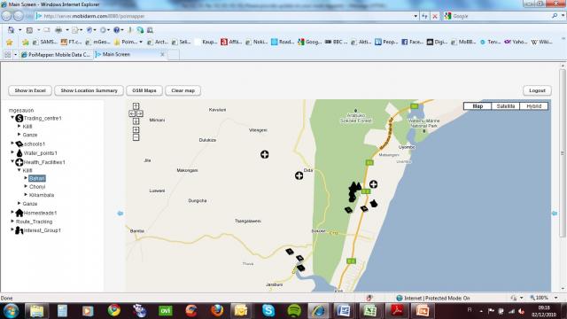 For example, PoiMapper can be used to track information on schools in region. During a revisit, instead of completing a new form or questionnaire -- on number of students, teachers, closets, sinks and toilets, say -- a field worker could look at previous data and just update the values. The worker could also take pictures of the school and facilities from a mobile phone and tie this image to the specific school entry in the database. If the school is located in an area with no data connectivity, information is stored on an external memeory card to be uploaded later. The database can be exported to Excel for formatting and analysis. Points of interest can also be plotted on a Google map.
One important feature of PoiMapper is that it works on feature phones, the cheapest of which can cost around USD 40. The system was designed for people who are doing work for an organization - be they field workers, volunteers, or villagers in remote locations.
Other key features are highlighted in this blog post:
- Multiple front ends: standard internet browsing for laptops and large screen smart phones and mobile browsing (WAP)
- Dedicated application for GPS enabled mobile phones
- Authoring tool for defining forms and corresponding database model for storing the collected data
- Open API for accessing stored data
- Based on a SaaS model
Challenges and successes
There have been both technical and user challenges to the PoiMapper application. One technical challenge arose when phones ran out of memory, Lounamaa said. This, in part, led to a redesign in which the service was changed from a survey approach to a database approach, where the majority of data is transferred and stored in the database.
Another bump emerged when users wanted to change the questionnaires over time. The system had to be designed to be easy to add and change questions, Lounamaa said.
But this ability to customize has been a strength for Njuguna in Kenya, as it lends flexibility to customize the system to the needs of Plan International. Another strength, Njuguna said, is the ability to use affordable, low-end mobiles. The application runs on a phone whose functionality is familiar, including the use of the basic mobile phone camera.
“Off-the-shelf” GIS applications might require specialized staff training and are not tailored to suite the program, Njuguna said. Plan staff in Kenya were trained for a week on PoiMaper, and were also involved in developing the specific POIs on which data was later collected.
Njuguna and his team are looking into better visualization tools -- i.e., a dashboard -- for maps and reports. As mentioned above, the route mapping aspect of PoiMapper is not yet fully developed and feedback from the pilot will speak to this. "The pilot is still ongoing and evaluation is to be done a month from now. However, it is clear that the PoiMapper data will be helpful in support of program design, monitoring and evaluation," Njuguna said.
After development, the tool will be available on the commercial market through Pajat Management in Finland.
Read more
In June, Linda Raftree wrote on her blog about mobile mapping tool mGeos, followed by a post on mGESA (Mobile Geographical Services for Africa), which is a tailored application of mGEOS.
The posts provide excellent background and an on-the-scene account of PoiMapper in action.
PoiMapper: Mobile Data Collection Through Points-of-Interest in Kenya Locations
PoiMapper, a product from Pajat, is a mobile application for data collection, hosting, and sharing. It works on a feature phone with Java capability and allows a user to design a case-specific questionnaire to collect field data, including numbers, text, and photo images. Through this, it supports the collection of point-of-interest (POI) data -- hence the name, PoiMapper -- and is currently being tested in this capacity in Kenya in collaboration with Plan Kenya, Plan Finland, Helsinki University of Technology, and University of Nairobi. The pilot is ongoing and an evaluation is to be done a month from now.
MobileActive.org spoke with Pertti Lounamaa, managing director at Pajat, and Peter Njuguna, ICT coordinator for Plan International in Kilifi, Kenya, to hear more about how PoiMapper works.
Lounamaa said that traditionally, we think of collecting information about points of interest “like dots on a map,” but systems like PoiMapper could help collect information about entire routes and systems, such as water and irrigation systems, and follow how they are working. For now, the application only maps specific points of interest.
The process of mobile data collection is evolving, and similar systems are available including the Open Development Kit on Android or EpiServer by DataDyne. All three are authoring tools by which a user can design, install, and execute a questionnaire on a mobile phone. PoiMapper attempts to use location data more effectively on accessible, low-cost phones; it works on any phone with GPS that is capable of downloading an application.
The Pilot in Kilifi, Kenya
Plan, an international children’s development organization, is nearing the end of a 4-month pilot in Kilifi, Kenya to use PoiMapper to create more detailed maps to support program interventions.
The pilot team targeted to map all the homesteads in one location, Jaribuni. The team designates 3 days a month for the staff to do intensive mapping with PoiMapper and a total of 27 program staff are involved. Already, with some of the points collected, it is possible to do analysis on the data and answer some program design questions.
Njuguna said that the PoiMapper pilot initiative will lead to the development of GIS software for both mobiles and computers, and will ensure that technology is used to improve maps in terms of their accessibility and ability to provide more up-to-date and dynamic information.
Usable, effective maps are hard to come by in many areas. In Kenya, the area is vast and mapping can be time consuming. Maps often contain inadequate information, are static, inaccessible, and do not focus on the household-level. In addition, Njuguna said, there are limited resources and expertise in utilization of maps, as well as poor culture in reading maps. “Most people in Kenya would prefer to verbally ask for directions instead of reading maps,” he said. But, maps -- especially those that show the distribution of community facilities such as wells, hospitals, and schools -- are essential for Plan and others. The local government, for example, does not have detailed and sufficient geo-reference data of the communities and decisions on where to put facilities to guarantee access to communities “becomes often a thing based on best guess,” Njuguna said.
The pilot will test the functionality of the PoiMapper application, identify areas of improvement, determine the potential for scaling up, and increase awareness of the system as a potential tool for programming, monitoring, and evaluation. A bigger target of the pilot, Njuguna said, is to map the whole of Kilifi District in terms of all the POIs.
How it works
The PoiMapper application allows a user to create a case-specific questionnaire, collect data, and upload it to a database. PoiMapper also allows the user to take photographs of the POIs being recorded and these images are also uploaded to the database. Another feature is that the system can be used to update existing data.
For example, PoiMapper can be used to track information on schools in region. During a revisit, instead of completing a new form or questionnaire -- on number of students, teachers, closets, sinks and toilets, say -- a field worker could look at previous data and just update the values. The worker could also take pictures of the school and facilities from a mobile phone and tie this image to the specific school entry in the database. If the school is located in an area with no data connectivity, information is stored on an external memeory card to be uploaded later. The database can be exported to Excel for formatting and analysis. Points of interest can also be plotted on a Google map.
One important feature of PoiMapper is that it works on feature phones, the cheapest of which can cost around USD 40. The system was designed for people who are doing work for an organization - be they field workers, volunteers, or villagers in remote locations.
Other key features are highlighted in this blog post:
- Multiple front ends: standard internet browsing for laptops and large screen smart phones and mobile browsing (WAP)
- Dedicated application for GPS enabled mobile phones
- Authoring tool for defining forms and corresponding database model for storing the collected data
- Open API for accessing stored data
- Based on a SaaS model
Challenges and successes
There have been both technical and user challenges to the PoiMapper application. One technical challenge arose when phones ran out of memory, Lounamaa said. This, in part, led to a redesign in which the service was changed from a survey approach to a database approach, where the majority of data is transferred and stored in the database.
Another bump emerged when users wanted to change the questionnaires over time. The system had to be designed to be easy to add and change questions, Lounamaa said.
But this ability to customize has been a strength for Njuguna in Kenya, as it lends flexibility to customize the system to the needs of Plan International. Another strength, Njuguna said, is the ability to use affordable, low-end mobiles. The application runs on a phone whose functionality is familiar, including the use of the basic mobile phone camera.
“Off-the-shelf” GIS applications might require specialized staff training and are not tailored to suite the program, Njuguna said. Plan staff in Kenya were trained for a week on PoiMaper, and were also involved in developing the specific POIs on which data was later collected.
Njuguna and his team are looking into better visualization tools -- i.e., a dashboard -- for maps and reports. As mentioned above, the route mapping aspect of PoiMapper is not yet fully developed and feedback from the pilot will speak to this. "The pilot is still ongoing and evaluation is to be done a month from now. However, it is clear that the PoiMapper data will be helpful in support of program design, monitoring and evaluation," Njuguna said.
After development, the tool will be available on the commercial market through Pajat Management in Finland.
Read more
In June, Linda Raftree wrote on her blog about mobile mapping tool mGeos, followed by a post on mGESA (Mobile Geographical Services for Africa), which is a tailored application of mGEOS.
The posts provide excellent background and an on-the-scene account of PoiMapper in action.

Post new comment