population tracking
Posted by AnneryanHeatwole on Feb 14, 2012
After a disaster or humanitarian crisis, people often leave affected areas and resettle elsewhere. These population shifts can strain infrastructure and make it difficult to coordinate relief efforts when no one knows exactly where displaced individuals have gone. After the January 2010 earthquake in Haiti, more than one million Haitians were left homeless; in the ensuing months the country was hit by a cholera outbreak that has now killed roughly 7000 people. Two years after the earthquake, there are still nearly 500,000 people living in displacement camps across the country.
Haiti’s population movements, combined with the cholera outbreaks, highlight the importance of identifying areas where infrastructure is strained after disasters. In response, a recent research paper "Improved Response to Disasters and Outbreaks by Tracking Population Movements with Mobile Phone Network Data: A Post-Earthquake Geospatial Study in Haiti" examines how SIM card data can be used to draw conclusions about post-disaster population movements.
| Monitoring Populations by their SIM Cards: Flowminder Predicts Where People Go In Crises data sheet 3484 Views |
| Countries: |
Haiti
Sweden
|
Posted by AnneryanHeatwole on Feb 03, 2012
Improved Response to Disasters and Outbreaks by Tracking Population Movements with Mobile Phone Network Data: A Post-Earthquake Geospatial Study in Haiti data sheet 1344 Views
Author:
Linus Bengtsson, Xin Lu, Anna Thorson, Richard Garfield, Johan von Schreeb
Abstract:
Background
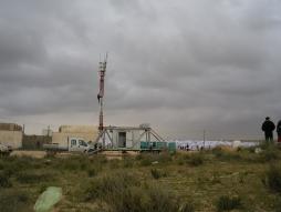
Population movements following disasters can cause important increases in morbidity and mortality. Without knowledge of the locations of affected people, relief assistance is compromised. No rapid and accurate method exists to track population movements after disasters. We used position data of subscriber identity module (SIM) cards from the largest mobile phone company in Haiti (Digicel) to estimate the magnitude and trends of population movements following the Haiti 2010 earthquake and cholera outbreak.
Methods and Findings
Geographic positions of SIM cards were determined by the location of the mobile phone tower through which each SIM card connects when calling. We followed daily positions of SIM cards 42 days before the earthquake and 158 days after. To exclude inactivated SIM cards, we included only the 1.9 million SIM cards that made at least one call both pre-earthquake and during the last month of study. In Port-au-Prince there were 3.2 persons per included SIM card. We used this ratio to extrapolate from the number of moving SIM cards to the number of moving persons. Cholera outbreak analyses covered 8 days and tracked 138,560 SIM cards.
An estimated 630,000 persons (197,484 Digicel SIM cards), present in Port-au-Prince on the day of the earthquake, had left 19 days post-earthquake. Estimated net outflow of people (outflow minus inflow) corresponded to 20% of the Port-au-Prince pre-earthquake population. Geographic distribution of population movements from Port-au-Prince corresponded well with results from a large retrospective, population-based UN survey. To demonstrate feasibility of rapid estimates and to identify areas at potentially increased risk of outbreaks, we produced reports on SIM card movements from a cholera outbreak area at its immediate onset and within 12 hours of receiving data.
Conclusions
Results suggest that estimates of population movements during disasters and outbreaks can be delivered rapidly and with potentially high validity in areas with high mobile phone use.
Posted by AnneryanHeatwole on Jan 31, 2012
Natural disasters and humanitarian crises can damage infrastructure, redistribute populations, and make it difficult for relief organizations to do their work; in these situations, mobile communications can be the best way to organize disaster relief efforts and provide early warning systems.
The GSMA has released finalists for the Global Mobile Awards (Editor's Disclosure: MobileActive's Katrin Verclas is a judge for the awards in the category focused on mobile programs for "Underserved Communities.")
The nominees in the "Best Use of Mobile in Emergency or Humanitarian Situations" struck us as particularly interesting. They demonstrate an interesting and varied use of mobile technology in an emergency. Here are a few.